 |
| Candleriggs - a road for just 2 hours a day |
This half of the area is a bit busier and livelier than its western counterpart and features a number of very popular Glasgow pubs and restaurants. If you aren't a resident but have visited Glasgow in the last 10-20 years or so, its likely you ended up here at some point - its particularly popular with away team's fans in search of a pre-match sing-along before heading for Celtic Park a few miles eastward, which can make for a slight cultural clash between the sometimes rowdy "fitba" fans outside the O'Neills enormo-pub and trendy gastrophiles heading for Cafe Gandolfi. The focal point is Merchant Square - an old indoor market that's been converted into space for trendy pubs and restaurants - it features a large central space for the craft fairs that frequent here every weekend. Adjoining it are a pair of (interconnected) music venues: The City Halls and The Old Fruitmarket, the former of which plays host to the Scottish Symphony Orchestra, while the latter caters for a variety of different equally classy events - it was most recently used for BBC Scotland's Hogmanay celebrations and the annual "Celtic Connections" festival. Thus both are key destinations for cultural connoisseurs of all stripes - the kind of places people might consider cycling to, in fact! (ahem... bit tenuous there...)
Candleriggs
 |
| Candleriggs looking south from Ingram Street - there's a car-park (another one!) |
Candleriggs is kind of "ground zero" for the Merchant City - the street along which most patrons will enter the area and where a number of the first new businesses opened during the 80s. The northern half of the street features (limited) on-street parking on the right, spacious foot-ways, double-yellows lines and paved streets with low kerbs. As you can see from the picture, there's also an open-air car-park, the ugliness of which is tempered by trees and a rather striking (and seasonally changing) mural on the wall.
 |
| Squint a bit and you could be in Amsterdam |
 |
| Wilson Street facing West - another mural overlooking the debris of Goldbergs |
Like its westward cousin Hutcheson Street, Candleriggs is one-way southbound and similarly fails to provide a cycle contraflow - yet another missed opportunity, particularly if it extended southwards to Trongate and King Street (to be fair though, I can't think of many one-way systems that could not be massively improved by allowing a contraflow).
As we reach Bell Street, something interesting happens, a feature which acts as a handy reminder that exploring infrastructure via Google Streetview can be misleading. If you look southward using that tool, at the moment you'll just see a street with traffic on it. However, this is what you'll see today:
 | |||
| Candleriggs looking South - Glasgow's newest pedestrian precinct |
 |
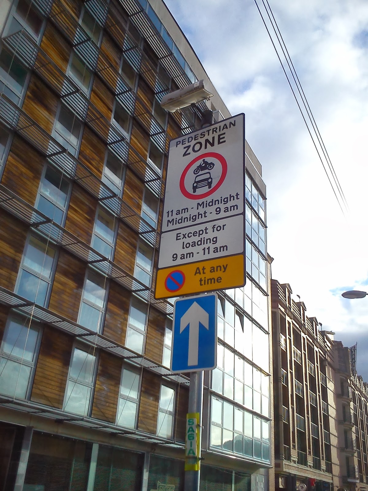
| No Parking - AT ANY TIME! Yet somehow this pub survives |
Questions remain though - if this is a pedestrianized zone, does it still count as a roadway? This is important because it would appear that the one-way system still exists for motor vehicles (when they are permitted), but I'd say there's a question mark over whether or not this would apply to bikes outside of the loading window - if it doesn't apply, there are positive implications for bikes (see analysis section below). One last anomaly - there's a set of traffic lights at the bottom of the street, which are still operational at all times, answering the question "if there's a set of traffic lights but no traffic to observe them, do they change?", which no-one has ever asked, in life...
Bell St and Albion Street


Albion Street is the rat-run par excellence - whilst there's a light-controlled junction at Trongate, taking this route allows drivers to avoid Glasgow Cross and High Street all the way to George Street, which can take as much as 20 minutes off a peak-time morning journey (no, really!). It's almost as if the highway engineers, having maintained their motoring temperance throughout the Merchant City, have fallen off the wagon in a big way. Albion Street is two way, and features on-street parking on both sides of the road for most of its length (aside from one section northbound directly in front of the City Halls), despite featuring (yet another) large carpark - the slightly mislabelled "Q-Park Candleriggs":
 |
| Wrong street, yo... |
 | |
| Northbound - no space for cycling here obviously |
 |
| The Advanced Stop Line - the work of the devil |
Whilst it's a marked improvement over the hellish race track/traffic jam of High Street, it's not terribly friendly is it? I took these pictures on a Sunday afternoon - hardly peak time, and yet there was an almost constant stream of vehicles driving along here from Trongate or via Bell Street's eastern two-way section (more on this later). The tragedy here is that this is a busy part of the city at night - you'll often see "refreshed" pedestrians running the gauntlet trying to cross the street between "O'Neills" and "The Libertine", skipping between parked cars and the ranks of taxis outside the "Arta" nightclub. There's a real need to reduce through traffic here, or at the very least to reduce their speed - why not extend the 20mph zone?
Blackfriars Street

 |
| Note the skewed geometry of the roadway |
Now if you look closely at the sign, it says "no vehicles", which would appear to technically include bikes, although I don't think this is the intention (there's cycle parking just on the right in the middle distance). It is still one-way, although again I wonder if this applies to bikes because, if not, here's a great little permeable short-cut between the student accommodation across the road and the greater city centre. A word of caution though: when I rode along here to take pictures, at least two cars followed after me and onto High Street, which suggests that a few folk haven't got the message yet... this is where enforcement comes into play (come on GCC!).
 |
| End on High Street - note the priority of the foot-way over the roadway |
 |
| This car shouldn't be here...but it is! |
High Street and Bell Street
 |
| Northbound on High Street |
- Its one of Glasgow's original streets - there's been settlements by the Clyde here since Roman times but High Street became important around the 12th Century after the founding of the Cathedral, which is about a Kilometre uphill from Glasgow Cross.
- In the middle of the last century, there was a plan to demolish this part of the city to make way for the eastern leg of the proposed city inner-ring road that would have completely encircled the centre - High Street would have been the site of that motorway.
In recent years, a large amount of student accommodation for nearby Strathclyde University has been built (visible on the right of the picture above) - in other words, we have a large residential community made up largely of pedestrians (and potential cyclists), cut off from the rest of the city by a very busy road and with few opportunities to cross.
 |
| Southbound on High Street - you can see the Tollbooth of Glasgow Cross in the background |
 |
| Junction of High Street and Bell Street |
Suffice to say, in the area relevant to the Merchant City, there's virtually no accommodation for cycles, beyond some token cycle parking outside High Street railway station and some ASLs at the junctions with Bell Street and Duke Street/George Street. Bell Street is much the same at this point. This is precisely where segregated infrastructure is essential.
Analysis
In the previous posting, I attempted to assess the success (or otherwise) of the strategy to reduce traffic flow through the western Merchant City - let's call it "the western cell", by examining and comparing the various routes through the area by car and contrasting them with cycling and walking. I'm going to continue that approach here with the Eastern "cell", although I think it's pretty clear from the get go, that there's a big problem already in the form of Albion Street/Bell Street. In any case, let's carry on.Starting with a scenario similar to last time, the route between Ingram street to Trongate, by car. This is how it was in the recent past (and still between the hours of 9am-11am):
View Larger Map
However, with the new pedestrianized zone, the route changes:
View Larger Map
Now, in reality, the lower speed limit in this area, plus the addition of two corners to negotiate, makes it more likely that the car route would actually be via Albion Street:
View Larger Map
Thus, by closing off the bottom of the road (even temporarily) and by reducing the speed limit, the incentive to use Candleriggs is significantly reduced. However, cycling that route is unaffected - it's still beneficial to travel this route (and with lower traffic, more attractive). The reverse is also true - going via Albion Street conveys an advantage over the "offical" driving route of going via Glasgow Cross/High Street, partly due to the absence of traffic lights at the junctions with Ingram Street and Bell Street.
Almost eclipsing this though, is another route which reinforces Albion Street's rat-run status. Heading East/West via Bell Street allows drivers coming from the East End to completely bypass Glasgow Cross/High Street. I'm going to expand the map slightly to illustrate a key use-case - leaving the M8:
View Larger Map
Although it seems counter-intuitive, this is a much faster route for heading east towards Calton, Darlmarnock and Bridgeton (assuming you didn't leave at the Parkhead junction further up) as it completely avoids both the junctions at the Royal Infirmary, Duke Street and Glasgow Cross. You get a similar gain in reverse, this time, heading for George Square:
View Larger Map
As far as cycling is concerned, the benefit of the pedestrianisation of Candleriggs is all dependent on whether or not the one-way system still applies (as above). Assuming that it does, it enables access to and from King Street - a main route from the South-side, although the lack of a contraflow the entire length of the street prevents what could be a useful means of avoiding Albion Street - the one-way system along Wilson Street does allow people on bikes to cross into the western cell to make use of routes north.
 |
| Potential Cycle Route North/West (Google Maps) |
If staying in the eastern cell though, one can't escape that cycles are effectively compelled onto cycling-unfriendly, Albion Street, which is a problem. There's also Bell Street's one-way system - if a contraflow was added, it would improve the east->west route time by allowing a connection with Wilson Street/Brunswick Street:
 |
| Potential E-W Cycle Route - (Google Maps ) |
Fundamentally, something needs to be done with Albion Street. Either motor vehicles have to be dissuaded from travelling along it, by implementing a similar one-way system as exists on other nearby streets - northbound would probably be the natural direction - or split the street with some sort of bike/taxi gate, perhaps just north of the junction with Bell Street. This would enable access to the various streets, but would eliminate through traffic, although care would have to be taken to prevent displacing south-bound traffic onto Blackfriars Street. If neither option was available, they need to make it easier for bikes to avoid Albion Street or provide some sort of separation along its length, which would probably require the elimination of most if not all the on-street parking. Perhaps a two-way route on the Southbound carriageway with proper priority over the eastern Bell Street junction would provide the safe route, as well as providing a disincentive for motor vehicles to use Bell Street for an East->West rat run.
...
In the next post, I'll take a look at the final part of what I'll call the "greater" Merchant City - namely the group of streets south of Trongate centred around King Street.
Great article!!
ReplyDeleteWe at university living provide such best-in-class student housing.
Check out this property on our website:
Keiller Court Dundee