Showing posts with label contraflow. Show all posts

Sunday, 4 May 2014

Shawlands and Strathbungo


Back to Glasgow now! After last weekend's bike débâcle, I finally managed to get my bike in for some attention at the repair shop. As I waited for it to be fixed, I decided to take a stroll around the area to get a coffee and a pastry, as one is wont to on an idle Saturday with no large cycle protests to attend.

Strathbungo

The shop sits on Pollokshaws Road in the heart of the South-side in a small area just north of Shawlands called Strathbungo - an interesting part of the city that straddles the line between more affluent Crossmyloof and Maxwell Park, and the less salubrious areas of Eglinton, (Eastern) Pollokshields and Queens Park. In recent years it's become a little enclave of bohemia, with boutique hipster brasseries like Gusto and Relish and The Bungo rubbing up against traditional working class stalwarts like Heraghtys and The Allison Arms. For a small area, there's quite a bit of cycle infrastructure on display, although it still falls down in key areas of safety and directness.


View Larger Map

Strathbungo lies at the centre of a couple of key local through routes, specifically the North-South route along Pollokshaws Road and East-West routes along Calder Street, Allison Street and Nithsdale Drive/Road/Street, as well as bisecting a couple of train-lines. About 10-15 years ago, traffic routes were amended to create a gyratory system - plans which were vigorously opposed by local businesses and residents - which involved a implementing several one-way streets and the closing off roads to through motor traffic.

At the same time, some cycle-specific elements were implemented to complement. Most of it still survives, but as with a lot of contemporary infrastructure, without maintenance it has deteriorated somewhat. At the same time, there are some ideas that were implemented at the time which seem - in hindsight, quite forward thinking. For example, all the way up Pollokshaws Road, there are examples of raised pavements at junction which give the impression of pedestrian priority.

The concept is good - if only it could be extended to complementing cycle paths
As we shall see later, regrettably this approach seems to have been abandoned for newer projects -  because it's difficult to keep maintained or because it annoys drivers? There's also an example along Torrisdale Street of our old friend the cycle contra-flow, except this time its a fully protected example, whilst still maintaining vehicle parking.

It is possible - why not more of this?
It wasn't perfect though - it's under 100m long for a start. Perhaps it's difficult to see but the lane is also on the wrong side of the road for the direction its intended for (east to west) and is arguably too narrow for a bi-directional route, but the fact that this even exists shows that it's possible. In addition, if you continue the route further towards Queens Park and Victoria Road, you have a potentially useful low traffic route which is shorter than the driven equivalent.

You can also cross onto Nithsdale Road towards Maxwell Park
Regrettably, the reverse is not legal - the eastern end of Torrisdale Street is also one-way westbound, but lacks the cycle contra-flow element. This means that cycles heading eastwards need to divert onto the two-way section of Queen's Drive (albeit turning onto access-only Albert Avenue) or take a detour along Niddrie Road and virtually traffic-free Prince Edward Street - the Glaswegian equivalent of "Quietways".

The western half of Strathbungo resembles something close to the Woonerf's of the Netherlands, namely narrow roads primarily aimed at local access, except minus the lower speed limits. Motor vehicles haven't been removed here, but there's no through roads, with the exception of a narrow lane for bin lorry access at the rear by the railway line.

A little further south, we have another example of what you might call classic filtered permeability, albeit somewhat compromised by the lack of double yellow lines preventing parking across the mouth of the path.

No-one here today but usually that space is taken by a motor vehicle

Heading south along Pollokshaws Road towards Shawlands, you are struck by how wide the roadway is and how underused the space is. Again, Glasgow has done half the job, by taking away some general traffic lanes but without being brave or radical enough to the extra step to make cycling easy and pleasant. Again we have the raised pavements across minor roadways, but that seems to be more about traffic calming than prioritising pedestrians.

No space for cycling here?
As was customary for the time when it was developed cycle provision along here consists mainly of a shared bus-lane in the southbound direction, with nothing on the northbound carriageway. But there's also a median here which appears to serve no purpose that I can see - pedestrians can't (or wouldn't want to) cross here. The southbound pavement by the park is also pretty generous - I walked up here on a dry Saturday afternoon and there was barely any foot traffic other than the odd jogger.


View Larger Map

Continuing on to the border with Shawlands, I was struck by presence of street-lighting attached to the side of tenements, as opposed to the usual free-standing affairs.

A rare sight


Clearly it is possible to do that and, as Glasgow has retained a lot of its traditional sandstone tenements, it seems strange that they haven't made further use of this sort of arrangement. It would certainly help to reduce the plethora of street furniture that litters the pavements.

A pole - yesterday

Shawlands

And onto the crossroads at Langside Road where Shawlands really begins. My fellow Glasgow-based cycling blogger Darkerside has discussed Shawlands at length before, so I won't repeat all of his good work, but there have been a few changes since that post was written which bear comment.

There are apparently plans afoot to transform the area around the crossroads, specifically the Mitchell Halls and surrounds, to turn it into a form of civic square. As you can see in the map and my picture below, there's no shortage of space, but how to allocate it?


View Larger Map

Space for Posters but no space for bikes?
The problem here is the combination of the wide banking left turn (which acts as a traffic light by-pass - the lights across it are pedestrian signals only) and the bus lane. If they close off the left lane, I think the bus lane probably has to go too. Alternatively, they could be radical and ban left turns here altogether, although that would have the effect of forcing more southbound vehicles to stay on Pollokshaws Road, and thence travel through the warren of residential back streets between it and Tantallon Road.

The problem with adding zippy-looking pedestrian-orientated infra on busy through routes - without maintenance it deteriorates rapidly
A bit further along, a section of the main shopping street has been renovated recently (still incomplete), which has widened the eastern footpath considerably and replaced the tarmac with attractive, expensive-looking pink paving stones (similar to what has been done in Merchant City).

Now with added pinch points!


Regrettably, the have also removed some of the raised beds over the side streets, replacing this instead with dropped kerbs:

 
As it is now...
...as it was a little further up the road

Again, perhaps fashion has changed amongst Glasgow's highway engineers but it seems a shame that this idea has been discarded, given that it could work well if combined with segregated cycle paths.

The widened footpaths have definitely to be commended, and it was apparent that some of the local cafés had taken advantage by extending outdoor seating into it - precisely the kind of thing that makes an area seem much more pleasant. They have also retained the on-street parking, but yet again Glasgow has failed to take into account cycling into the design plan.

This new section corresponds to the footprint of the much-reviled Shawlands Arcade on the western side of the carriageway. Space for the extended pavement has been reclaimed by removing the totally unnecessary central reservation, but I would argue that even more could be done by either entirely removing parking from the western side or by reducing the width of the pavement.


View Larger Map

Now I appreciate the latter suggestion seems a bit extreme, but there's a good reason I make it. The footpath at the roadside only really serves the people who park on the road there - the shops are in an elevated promenade and there are only a couple of entrances for pedestrians at either end of the arcade area. Assuming the Arcade stays in its present form (not a given but there are no current plans to demolish it as far as I'm aware), pedestrian through traffic mainly limits itself to the promenade area. Removal of parking would be a more palatable choice but every bit as contraversial, but there is a relatively un-tapped resource - the Arcade's own 300-space car park, which is free for the first 60 minutes. There have clearly been attempts to promote its use recently, as evidenced here:


That provision easily out-numbers the on-road capacity and is significantly cheaper - all it requires is a bit of consultation and some promotion to change driver behaviour to accept this, and all that under-used space could be freed up for better northbound cycle provision (or indeed creating a wide bi-directional path), whilst still retaining loading facilities on the southbound carriageway.

At the top of the shopping area, its difficult not to conclude that something could be done to improve provision here. Look at all the sheer amount of roadspace  in the next picture:

Feel the width!
The room is there, we just need the will. And for all its faults, Shawlands still manages relatively well - the Arcade aside, most of the shops that line Pollokshaws and Kilmarnock Road are populated and not just by charity shops and bookies. There are green grocers, butchers, bakers, little fashion boutiques, as well as a slew of little coffee-shops, restaurants and bars. I even nipped in to "EAT" cafe on the way back - the place that had chided Glasgow City Council for raising parking rates. Maybe if they paid more attention to where there customers actually came from, they'd be more positive about the changes in the area.

Sunday, 23 February 2014

Merchant City: Part 4

We're coming to the end of my examination of the Merchant City, and once again there's the hint of me cheating slightly by including this extra part. The area south of Trongate doesn't technically come under "Merchant City" but it would foolish to ignore it, given that there are some notable infrastructural elements that bear further discussion, plus it "feels" naturally to be an extension of the area. "Lower Merchant City" seems a bit degrading and doesn't reflect the distinctive character of this area, so I'm going to take a bit of a leap and maybe coin a new term: SoTro, or "South of Trongate" (... hmmm maybe needs a bit of work "BeGa": "Between the Gates"?).

This mainly residential area of an old fashioned sort - groups of tenements above shops - an increasing rare type of arrangement nowadays. You won't find a pawnshop, charity shop or bookies around here though - the majority of the retailers around here serve niche markets, with clusters of them devoted to art, board games, comic books and - for reasons I can't sufficiently account for - a concentration of tattooist parlours. Where the Merchant City proper is expensive, yuppie-ish and glamorous, SoTro is bohemian and trendy - the kind of place moustachioed hipsters on fixies would be wont to go and be seen. Adding to this flavour are a number of music/art-orientated cafes, bars and restaurants, including the famous 13th Note Cafe - a stalwart of underground Glasgow Indie, Punk and Rock for the last 20 years, as well as being a vegetarian restaurant. For those to whom that isn't pure enough, there's always vegan fare available over in nearby Mono


Despite it's small area, there's a few things to cover, and it's strategic position by the Clyde makes it every bit as significant for cycles as its northern neighbour.

King Street

King Street Looking South from Candleriggs
The area pivots around King Street, which we've already encountered before. King Street provides the link between Bridgegate - another ancient Glasgow thoroughfare, now mainly reduced to a one-way four lane racetrack for motor vehicles coming over the Victoria Bridge which have been diverted away from Stockwell Street by the bus-gate (more on this later).

King Street itself is one-way for cars but is two-way for bikes, courtesy of the cycle contraflow, marked out by painted lines and small traffic islands at the end of its junctions with Trongate and Parnie Street. Regrettably, this lane places bikes adjacent to the door zone of parked cars, although in mitigation it is the car's offside, rather than nearside. In addition, the lane is both more generously proportioned than is typical for this sort of arrangement and users ride facing the flow of traffic, meaning that car passengers are at least looking in their direction, thus reducing the likelihood of someone blindly opening the door (and increasing the chance of the rider anticipating that happening).
Contraflow lane - door-zone(ish)


Following the lane southbound, we arrive at the crossroads junction with Parine Street, an eastbound one-way street - note the traffic island (replete with damaged sign-age):

Junction of Parnie Street. Give way to... what exactly?

Now as you can see, the cycle lane gives way to traffic from the right. There's a missed opportunity here to prioritise bikes across the junction. Northbound traffic on King Street already gives way to the left i.e. the western, two-way section of Parnie Street, which is a de-facto dead-end*. Traffic rarely comes from that direction, thus northbound traffic will tend to blow through the junction as if they have priority (albeit cautiously). Implementing a raised table, in other words raising the crossroads up to meet the pavement, removing the give way lines (thus creating a form of "unmarked crossroads") and prominently outlining a cycle lane with either paint or (preferably) a different road surface would give actual and perceived priority to southbound cycles. The desirability for northbound vehicles turning right here is already diminished (see next section), thus it seems natural to reinforce the primacy of southbound bikes even further.

2nd half of the contraflow. No priority here for bikes
 Moving further down the street after the interruption at the junction, we have another short section of cycle contraflow, until we reach the 2nd junction with Parnie Street (see below). This marks the end of the contraflow and the special cycle provision, but it ends with a unique flourish - cycle-specific traffic lights.

A little green bike means "go"
The utility of these bike-only lights is tarnished slightly by being placed at the normal height traffic light height - given that they've presumably went to the trouble of obtaining a TRO for both the contraflow and the bike-specific green light, taking that one step further and fitting eye-level signals would surely have been worthwhile.  Further Southbound on King Street takes us to Bridgegate (the aforementioned race-track) which is regrettably impermeable (despite ample opportunity), and thence onto Saltmarket.

Kings Court Panorama
I'm including this last picture of Kings Court - a small triangular plaza with an array of shops on two sides - to contrast the provision for bikes versus motor vehicles. The cycle parking here only consists of two small (exposed) sheffield stands. Compare this to the row of on-street parking and yet another large (open-air) car-park just out of shot on the right. Making provision for cycling isn't just about adjustments to roads and suchlike - it needs to be made convenient for when you arrive at your destination too, which means providing more cycle stands (preferably sheltered) or indeed allowing people to take their bikes indoors.

(*) strictly speaking, it is legal to drive down "New Wynd", but that is a very narrow lane, usually blocked by bins and suchlike - pretty much the only traffic going along here consists of vehicles accessing the side of the Britannica Panopticon Music Hall and refuse lorries.

Parnie Street

Parnie Street looking East
A bike shop on Parnie Street - they love bikes "alot"(sic)
Parnie Street is a strange beast, although quite a good example of creating a space with little through traffic but without necessarily removing residential car parking - something more could be done to improve it though.

As said above, from the northern junction with King Street to its southern junction... with King Street, it's a one-way street (Eastbound). The little quirk I hint at above is due to the odd layout, which virtually doubles back on itself, hairpin-like. As this is also quite an old bit of the city, presumably in the past the roadway has been physically joined to Saltmarket, which would have meant an appreciable level of through traffic. Fortunately, forward-thinking highway engineers of the past closed off that junction and laid a footway instead. Happily, in more recent times they've added a cycle pathway here too, thus allowing cycles to legally traverse the gap with Saltmarket.

Archetypal Filtered Permeability between Parnie Street and Saltmarket

Unfortunately, this merely leads to a toucan crossing, which in turns leads to a narrow shared footway. I'm not sure what else they could have practically done here but the shared space element is a definite failure. You have to get across busy Saltmarket somehow - a zebra crossing on a raised table would be an option perhaps? It is a potentially significant route as it leads to the new segregated infrastructure, which will be the subject of a future posting.

Chisholm Street looking north -  Albion Street in the background
Chisholm Street is also one-way and directs traffic onto Parnie Street, notable only in that it is effectively a continuation of Albion Street, albeit separated by traffic lights. As with King Street and it's right turn, the one-way system prevents this from being a particularly useful through road, or at least makes the route circuitous, whilst still providing local access*. Like Parnie Street itself, there is no actual on-road cycle provision, and no cycle parking either, although the relatively quiet nature of the road compatible with safe for cycling here.

After the dogleg, Parnie Street meets King Street again and continues west towards Stockwell Street, where right-turns are prohibited for motor vehicles other than buses and taxis, thus preventing its use as a means of by-passing the bus-gate south of the junction (and thus preventing journeys via Glassford Street).

(*) Edit: Since writing this, I have travelled this route by car and can advise that I was wrong - this route IS potentially rat-runnable. I've amended the Analysis section accordingly

Trongate and Glasgow Cross

Glasgow Cross Panorama from South-east to West - the road was so busy it was impossible to get a clean shot
Like High Street in the previous posting, it's arguable that Trongate and Glasgow Cross should be the subject of their own posting, but for the lack of any actual cycle infrastructure. As said before, Glasgow Cross is the ancient heart of mediaeval Glasgow and its wide piazza-like extent reflects this. This could be Glasgow's equivalent of Times Square or Piccadilly Circus, albeit without the neon advertisements. Unlike its American counterpart (and to a degree, more like it's English one) there hasn't been any attempt to humanize this area by introducing a pedestrianized zone, nor has there been a serious attempt to curtail motor vehicle flow. Couple this with its strategic position as a major crossroads between East/West and North/South flowing traffic, as well as linking Clyde crossings to the M8 motorway junction at the top of High Street, you have all the hallmarks of gridlock. This isn't helped by the irregular five-pointed nature of the cross, with two easterly routes (London Road and Gallowgate) bissecting Saltmarket/High Street, meaning that three sets of traffic lights have to been traversed if travelling either north or southbound, as well as having to negotiate an awkward semi-roundabout at the Toolbooth. To put it bluntly, its a nightmarish guddle during peak travel hours, best avoided (hence the rat-running).

Westbound on Trongate
Despite what I said above, there is actually some attempt to moderate traffic flow, with the judicious use of one-way systems (in effect turning the whole cross into a large, dissipated, signal-controlled roundabout) and a single bus lane on the southern westbound carriageway, which of course admits bikes. There are ASLs on the northbound carriageway at Saltmarket, and westbound on London Road, but interestingly none going East or Southbound, which suggests that either there isn't deemed to be sufficient space for them or they aren't intended for bikes in those directions. Another post will possibly cover this (when discussing the new segregated infrastructure).

Panorama of Trongate's junction with Albion Street and Chisholm Street, looking north-west
Other than what's already been covered, there's not much else to discuss regarding Trongate. In the Part 2, I mentioned "Old Wynd" in connection with the slightly unfriendly pathway to Brunswick Street. Here it is below. It joins to a road which links to ... Parnie Street. As is the way of these things, it tends to double as an impromptu al-fresco urinal for refreshed pedestrians and is quite confined and unappealing at night, reducing its usefulness as a short-cut for people on bikes.
Old Wynd - ironically newer than "New Wynd"

Moving Westwards again, we cross Glassford Street again and reach Argyle Street, specifically its pedestrianized precinct, which extends to the junction with Queen Street, with a widened footway extending to Central Station. Notice that the "road" is demarcated with different coloured paving stones - there is limited access here for loading (like Candleriggs at very limited times) and this is technically the route down which bikes ought to travel:

Argyle Street's Pedestrian Precinct - allows bikes

The blog comes full circle by arriving back at the junction with Virginia Street, which we established in Part 1 permits bikes to pass between them:
Looking north along Virginia Street from Argyle Street

Analysis

Some of the analysis of routes has already been covered in previous postings but its worth reiterating the problems with King Street - its current design ensures that it forms the backbone of a northbound rat-run - given the retail and residential nature of parts of the area it runs through, there is far too much unnecessary through traffic - it is simply too easy to drive into the city centre this way, compared to other routes.

I believe the solution is relatively simple: prohibit right turns for motor vehicles at the junction with Trongate. Combined with closing off Hutcheson Street (as described in Part 2), the result would be that the only meaningful journey which could be made via this route is a loop back down Stockwell Street, a route made pointless by an existing shorter one via Parnie Street. As such, through traffic would be drastically reduced, whilst local access would be retained and (crucially) cycle traffic would remain uninhibited.

It would still be possible to reach all the same parts of the city in a car, but access would be constrained to a handful of circuitous, time-consuming routes and would inevitably involve travel along busy thoroughfares (Saltmarket, Glasgow Cross and High Street) - these main roads would then be treated to the various segregation/separation techniques the Dutch currently apply to their equivalent routes. The changes I propose are inexpensive and could be trialled temporarily as part of a traffic study. The fact that it's so easy makes me wonder if this idea hasn't already been considered and subsequently dismissed for whatever reason.

Edit: There is another (partial) rat-run I hadn't properly considered before: travelling southbound from Albion Street to The Albert Bridge via Chisholm Street:

(c) Google Maps
The usefulness of this route is tempered slightly by there being a number of traffic lights to drive through, although at least one of which is quite easy to traverse, whereas some the junction at Glasgow Cross can take several cycles to cross.

Glasgow Cross and High Street require further study - I suspect the solution will have to involve big detours to circumvent the whole area, perhaps incorporating the Clyde Gateway road scheme. Another post will discuss this in the future.

Saturday, 22 February 2014

Merchant City: Part 3

Candleriggs - a road for just 2 hours a day
Okay, so far we've assessed the western part of the Merchant City with some mixed but generally positive results. Now we'll look at the eastern side, the part you could just about see looking eastward along Wilson Street.

This half of the area is a bit busier and livelier than its western counterpart and features a number of very popular Glasgow pubs and restaurants. If you aren't a resident but have visited Glasgow in the last 10-20 years or so, its likely you ended up here at some point - its particularly popular with away team's fans in search of a pre-match sing-along before heading for Celtic Park a few miles eastward, which can make for a slight cultural clash between the sometimes rowdy "fitba" fans outside the O'Neills enormo-pub and trendy gastrophiles heading for Cafe Gandolfi.  The focal point is Merchant Square - an old indoor market that's been converted into space for trendy pubs and restaurants - it features a large central space for the craft fairs that frequent here every weekend. Adjoining it are a pair of (interconnected) music venues: The City Halls and The Old Fruitmarket, the former of which plays host to the Scottish Symphony Orchestra, while the latter caters for a variety of different equally classy events - it was most recently used for BBC Scotland's Hogmanay celebrations and the annual "Celtic Connections" festival. Thus both are key destinations for cultural connoisseurs of all stripes - the kind of places people might consider cycling to, in fact! (ahem... bit tenuous there...)

Like Wilson Street further west, Bell Street provides the central pivot around which the other streets radiate. This part of the Merchant City shows the difference between pedestrian-friendly and permeable, versus car-centric through road most starkly.

Candleriggs

Candleriggs looking south from Ingram Street - there's a car-park (another one!)

Candleriggs is kind of "ground zero" for the Merchant City - the street along which most patrons will enter the area and where a number of the first new businesses opened during the 80s. The northern half of the street features (limited) on-street parking on the right, spacious foot-ways, double-yellows lines and paved streets with low kerbs. As you can see from the picture, there's also an open-air car-park, the ugliness of which is tempered by trees and a rather striking (and seasonally changing) mural on the wall.

Squint a bit and you could be in Amsterdam
It's notable that this area features a mandatory 20mph speed limit, reinforced by the narrow roadway. This doesn't appear to extend to the western end - a quick check of the junction of Bell Street and Albion Street reveals the 30 limit being restored, but there isn't an equivalent at the end of the one-way system on Wilson Street - is this an oversight or a deliberate error? It would make sense to impose this limit throughout the area, and perhaps might discourage rat-running (more on this later).

Wilson Street facing West - another mural overlooking the debris of Goldbergs

Like its westward cousin Hutcheson Street, Candleriggs is one-way southbound and similarly fails to provide a cycle contraflow - yet another missed opportunity, particularly if it extended southwards to Trongate and King Street (to be fair though, I can't think of many one-way systems that could not be massively improved by allowing a contraflow).

As we reach Bell Street, something interesting happens, a feature which acts as a handy reminder that exploring infrastructure via Google Streetview can be misleading. If you look southward using that tool, at the moment you'll just see a street with traffic on it. However, this is what you'll see today:

Candleriggs looking South - Glasgow's newest pedestrian precinct


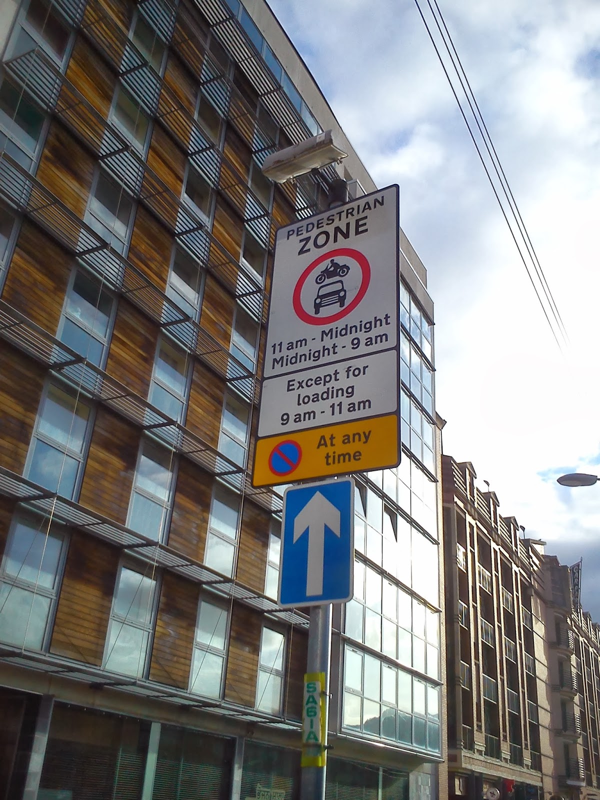
As you can see, they've only gone and pedestrianized the lower half of the street! Yes indeed, for 22 hours a day (i.e. except between 9 and 11am), all motor vehicles are banned. You can see little retractable bollards in front of the planters - these seem to be permanently upright. It looks to me as if there's another bollard in the centre which has been left folded down - this means that cars will still be able to squeeze through and it remains to be see the degree to which this new rule will be enforced, but if successful, I think it could be a major boon for the street. It blocks what was previously another potential rat-run, whilst allowing bikes and pedestrians unfettered access, all while still allowing loading to the local businesses and any emergency vehicles should they require it.
No Parking - AT ANY TIME! Yet somehow this pub survives

Questions remain though - if this is a pedestrianized zone, does it still count as a roadway? This is important because it would appear that the one-way system still exists for motor vehicles (when they are permitted), but I'd say there's a question mark over whether or not this would apply to bikes outside of the loading window - if it doesn't apply, there are positive implications for bikes (see analysis section below). One last anomaly - there's a set of traffic lights at the bottom of the street, which are still operational at all times, answering the question "if there's a set of traffic lights but no traffic to observe them, do they change?", which no-one has ever asked, in life...

Bell St and Albion Street


I told you there would be a big contrast here. Bell Street itself represents this change quite well. Look at the picture on the right. You see a fairly pleasant-looking semi-pedestrian one-way street (albeit with some car parking on the right). In the background you can just about see the junction with Albion Street, replete with stream of cars. This is where we revert back to business as usual unfortunately.

Albion Street is the rat-run par excellence - whilst there's a light-controlled junction at Trongate, taking this route allows drivers to avoid Glasgow Cross and High Street all the way to George Street, which can take as much as 20 minutes off a peak-time morning journey (no, really!). It's almost as if the highway engineers, having maintained their motoring temperance throughout the Merchant City, have fallen off the wagon in a big way. Albion Street is two way, and features on-street parking on both sides of the road for most of its length (aside from one section northbound directly in front of the City Halls), despite featuring (yet another) large carpark - the slightly mislabelled "Q-Park Candleriggs":

Wrong street, yo...
Perhaps you think I'm being a bit precious, but I think it bears repeating: there are at least three car parks within easy walking distance of anywhere in the Merchant City. Why do we need this much on-street parking? The problem I have with on-street parking is that its presence is often used as a excuse for why there's "no space for cycling", particularly on narrower urban streets with residential properties. Even where cycling is tolerated or even nominally accommodated with on-street cycle lanes, these are almost always routed on the nearside of parked cars within the door zone. I find that bewildering, particularly here where the road way is self-evidently wide enough - being at least four lanes. These are meter-controlled parking bays, which at least suggests someone thinks parking needs to be controlled.

Northbound - no space for cycling here obviously
It's probably worth noting that the southern junction of Albion Street features our old friend, the Advanced Stop Line, which suggests that the engineers intend for people on bikes to use this route southbound.

The Advanced Stop Line -  the work of the devil

Whilst it's a marked improvement over the hellish race track/traffic jam of High Street, it's not terribly friendly is it? I took these pictures on a Sunday afternoon - hardly peak time, and yet there was an almost constant stream of vehicles driving along here from Trongate or via Bell Street's eastern two-way section (more on this later). The tragedy here is that this is a busy part of the city at night - you'll often see "refreshed" pedestrians running the gauntlet trying to cross the street between "O'Neills" and "The Libertine", skipping between parked cars and the ranks of taxis outside the "Arta" nightclub. There's a real need to reduce through traffic here, or at the very least to reduce their speed - why not extend the 20mph zone?

Blackfriars Street

This little street is kind of interesting in a small way - it reminds me of the sort of street you see in smaller continental European towns - narrow, one-way, paved, a little parking - you just need a rusty Vespa and some situationist graffiti to complete the scene. As the name suggests, its quite an old street, dating to Mediaeval Glasgow, when it used to lead to a Dominican Abbey on High Street (hence the "black" in blackfriars), which subsequently became an early site for Glasgow University, one of Britain's oldest higher educational institutions (along with St. Andrews, Cambridge and Oxford). It is also home a cracking pub/Inn called Babbity Bowster - worth popping in for a pint en route to the Cathedral. But I digress... If we venture further eastwards, the street becomes a pedestrianized zone:
Note the skewed geometry of the roadway

Now if you look closely at the sign, it says "no vehicles", which would appear to technically include bikes, although I don't think this is the intention (there's cycle parking just on the right in the middle distance). It is still one-way, although again I wonder if this applies to bikes because, if not, here's a great little permeable short-cut between the student accommodation across the road and the greater city centre. A word of caution though: when I rode along here to take pictures, at least two cars followed after me and onto High Street, which suggests that a few folk haven't got the message yet... this is where enforcement comes into play (come on GCC!).

End on High Street - note the priority of the foot-way over the roadway


This car shouldn't be here...but it is!

High Street and Bell Street

Northbound on High Street
I'm not going to spend too much time here, because it's arguable whether or not High Street is a constituent part of the Merchant City, but it's very significant when it comes to Glasgow's transport network for a few reasons:
  1. Its one of Glasgow's original streets - there's been settlements by the Clyde here since Roman times but High Street became important around the 12th Century after the founding of the Cathedral, which is about a Kilometre uphill from Glasgow Cross.
  2. In the middle of the last century, there was a plan to demolish this part of the city to make way for the eastern leg of the proposed city inner-ring road that would have completely encircled the centre - High Street would have been the site of that motorway.
High Street is still one of Glasgow's major thoroughfares, linking two routes over the Clyde with the north and eastern part of the city, specifically Townhead, Springburn, Royston, Dennistoun and beyond. The top of the street is also a major junction of the M8 motorway - the northern leg of the incomplete ring road. Depending on the direction, this is one of the main junctions for vehicles coming to and from Edinburgh. Lastly, it is also the site of a large hospital, the Royal Infirmary. All this while being no wider than a typical urban street - tree-line boulevard it ain't. As such, it can be exceptionally busy even at off-peak times.

In recent years, a large amount of student accommodation for nearby Strathclyde University has been built (visible on the right of the picture above) - in other words, we have a large residential community made up largely of pedestrians (and potential cyclists), cut off from the rest of the city by a very busy road and with few opportunities to cross.

Southbound on High Street - you can see the Tollbooth of Glasgow Cross in the background

Junction of High Street and Bell Street

Suffice to say, in the area relevant to the Merchant City, there's virtually no accommodation for cycles, beyond some token cycle parking outside High Street railway station and some ASLs at the junctions with Bell Street and Duke Street/George Street. Bell Street is much the same at this point. This is precisely where segregated infrastructure is essential.

Analysis

In the previous posting, I attempted to assess the success (or otherwise) of the strategy to reduce traffic flow through the western Merchant City - let's call it "the western cell", by examining and comparing the various routes through the area by car and contrasting them with cycling and walking. I'm going to continue that approach here with the Eastern "cell", although I think it's pretty clear from the get go, that there's a big problem already in the form of Albion Street/Bell Street. In any case, let's carry on.

Starting with a scenario similar to last time, the route between Ingram street to Trongate, by car. This is how it was in the recent past (and still between the hours of 9am-11am):


View Larger Map

However, with the new pedestrianized zone, the route changes:


View Larger Map

Now, in reality, the lower speed limit in this area, plus the addition of two corners to negotiate, makes it more likely that the car route would actually be via Albion Street:


View Larger Map

Thus, by closing off the bottom of the road (even temporarily) and by reducing the speed limit, the incentive to use Candleriggs is significantly reduced. However, cycling that route is unaffected - it's still beneficial to travel this route (and with lower traffic, more attractive). The reverse is also true - going via Albion Street conveys an advantage over the "offical" driving route of going via Glasgow Cross/High Street, partly due to the absence of traffic lights at the junctions with Ingram Street and Bell Street.

Almost eclipsing this though, is another route which reinforces Albion Street's rat-run status. Heading East/West via Bell Street allows drivers coming from the East End to completely bypass Glasgow Cross/High Street. I'm going to expand the map slightly to illustrate a key use-case - leaving the M8:


View Larger Map

Although it seems counter-intuitive, this is a much faster route for heading east towards Calton, Darlmarnock and Bridgeton (assuming you didn't leave at the Parkhead junction further up) as it completely avoids both the junctions at the Royal Infirmary, Duke Street and Glasgow Cross. You get a similar gain in reverse, this time, heading for George Square:


View Larger Map

As far as cycling is concerned, the benefit of the pedestrianisation of Candleriggs is all dependent on whether or not the one-way system still applies (as above). Assuming that it does, it enables access to and from King Street - a main route from the South-side, although the lack of a contraflow the entire length of the street prevents what could be a useful means of avoiding Albion Street - the one-way system along Wilson Street does allow people on bikes to cross into the western cell to make use of routes north.
 

Potential Cycle Route North/West (Google Maps)

If staying in the eastern cell though, one can't escape that cycles are effectively compelled onto cycling-unfriendly, Albion Street, which is a problem. There's also Bell Street's one-way system - if a contraflow was added, it would improve the east->west route time by allowing a connection with Wilson Street/Brunswick Street:

Potential E-W Cycle Route - (Google Maps )

Fundamentally, something needs to be done with Albion Street. Either motor vehicles have to be dissuaded from travelling along it, by implementing a similar one-way system as exists on other nearby streets - northbound would probably be the natural direction - or split the street with some sort of bike/taxi gate, perhaps just north of the junction with Bell Street. This would enable access to the various streets, but would eliminate through traffic, although care would have to be taken to prevent displacing south-bound traffic onto Blackfriars Street. If neither option was available, they need to make it easier for bikes to avoid Albion Street or provide some sort of separation along its length, which would probably require the elimination of most if not all the on-street parking. Perhaps a two-way route on the Southbound carriageway with proper priority over the eastern Bell Street junction would provide the safe route, as well as providing a disincentive for motor vehicles to use Bell Street for an East->West rat run.

...

In the next post, I'll take a look at the final part of what I'll call the "greater" Merchant City - namely the group of streets south of Trongate centred around King Street.